

Introduction
Map Airport Copenhagen (CPH), also known as Københavns Lufthavn, is Denmark’s largest and busiest airport, serving as a major hub for travelers in Scandinavia. Whether you’re a first-time visitor or a frequent flyer, understanding the airport’s layout and facilities can help you navigate smoothly. This guide provides an in-depth look at the map of Copenhagen Airport, including terminals, transportation, and amenities.

Overview of Copenhagen Airport
Located approximately 8 kilometers (5 miles) southeast of Copenhagen city center, Copenhagen Airport is a well-organized international gateway. It is divided into multiple terminals, each serving specific airlines and flight routes. The airport is known for its efficiency, modern design, and excellent passenger services.
Key Features of Copenhagen Airport
- Multiple terminals with clear signage and passenger-friendly services.
- Over 60 airlines operating domestic, European, and international flights.
- Direct connectivity to Copenhagen city via metro, train, bus, and taxi.
- Comprehensive facilities including shopping, dining, and business lounges.
- Sustainable airport initiatives, including energy-efficient buildings and waste reduction programs.
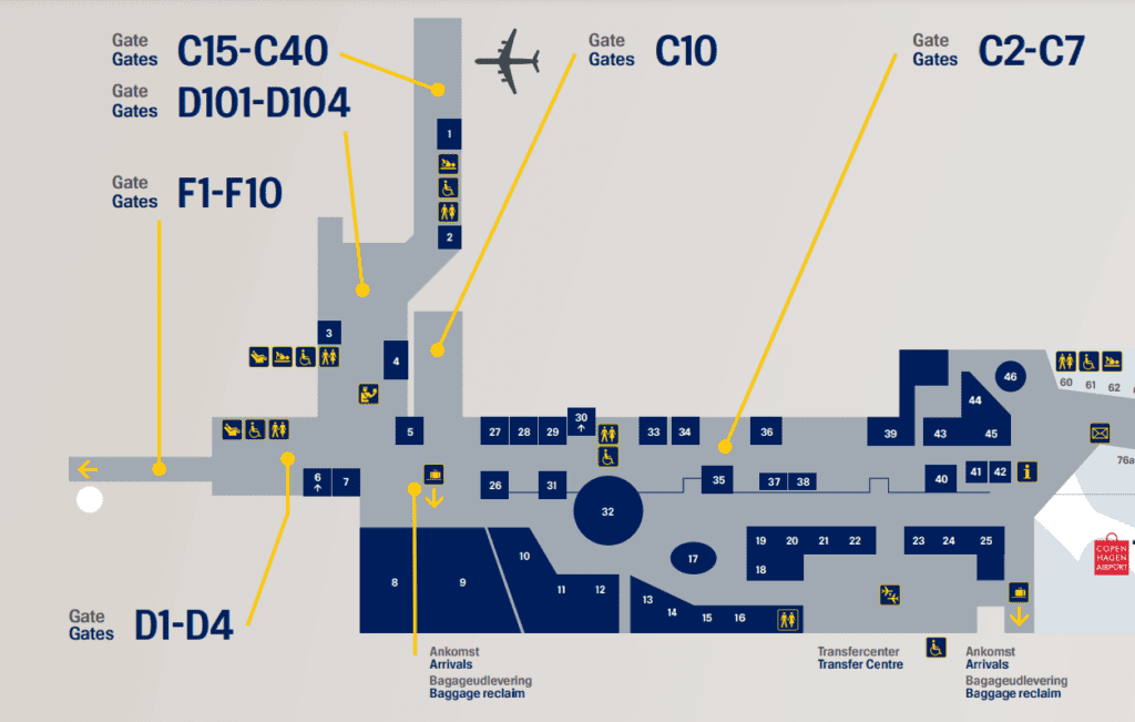
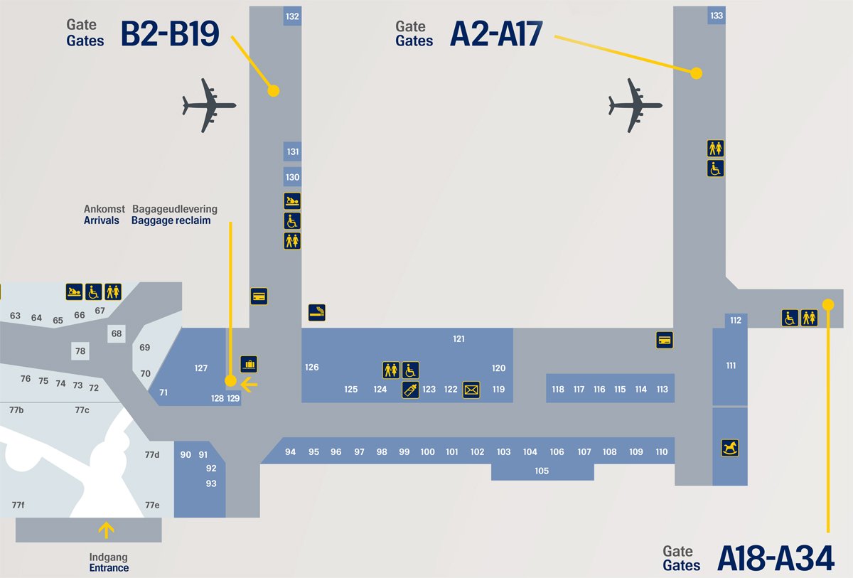
Terminals at Copenhagen Airport
Copenhagen Airport consists of three terminals:
Terminal 1 (Domestic Flights – Now Integrated)
Previously used for domestic flights, Terminal 1 has been merged into the main terminal complex. All flights now operate from Terminals 2 and 3.
Terminal 2 (Schengen and Non-Schengen Flights)
- Serves both Schengen and Non-Schengen destinations.
- Airlines like SAS, Norwegian, and easyJet operate from here.
- Equipped with a range of shops, restaurants, and lounges.
- Features automated self-check-in kiosks and fast-track security lanes.
Terminal 3 (International and Long-Haul Flights)
- Primarily used for long-haul and intercontinental flights.
- Houses the baggage claim area and Copenhagen Metro station.
- Features Car Rental, Airport Hotels, and Airline Check-in Counters.
- Offers luggage storage and baggage wrapping services.
The two main terminals (T2 and T3) are connected, allowing passengers to walk seamlessly between them.
Interactive Map of Copenhagen Airport
Copenhagen Airport provides an interactive map on its official website to make navigation easier. This map allows travelers to:
- Locate their departure and arrival gates.
- Find restaurants, shops, lounges, and rest areas.
- Check locations of security checkpoints and customs offices.
- Identify baggage claim areas and car rental services.
- View real-time updates on flight departures and arrivals.
You can access the latest Copenhagen Airport map on their official website:
Features of the Interactive Map
1. Terminal Navigation
- Copenhagen Airport has two main terminals (Terminal 2 and Terminal 3). The interactive map provides a detailed layout of the terminals, showing boarding gates, passport control, customs, and check-in counters.
- Travelers can search for their departure gate or find the shortest route to baggage claim upon arrival.
2. Real-Time Flight Information
- The interactive map is linked to live flight updates, allowing users to track their flight status and check real-time departure and arrival times.
- Passengers can enter their flight number to get a guided route from check-in to their boarding gate.
3. Shops, Restaurants, and Lounges
- The map displays duty-free stores, cafes, restaurants, and VIP lounges.
- Users can search for specific brands, cuisines, or price ranges and find the nearest dining or shopping options.
- Business and first-class travelers can easily locate SAS Lounges and other VIP lounges on the map.
4. Transport & Parking Assistance
- The map shows public transport options, including Metro stations, taxis, rental car services, and bus stops.
- Travelers can find their way to Copenhagen Central Station via Metro or train connections.
- Parking areas, both short-term and long-term, are highlighted on the map with details on availability and pricing.
5. Facilities and Services
- The map provides information on:
- Restrooms and baby care rooms
- ATMs and currency exchange services
- Luggage storage and lost & found
- Medical assistance and first-aid stations
- Free Wi-Fi access points
6. Accessibility Features
- Travelers with reduced mobility can use the map to find wheelchair-accessible routes, elevators, and special assistance desks.
- The map supports audio guidance and larger fonts for visually impaired passengers.
7. Multi-Language Support
- The map is available in Danish, English, and other major languages, ensuring ease of use for international travelers.
How to Use the Interactive Map
- The interactive map is accessible via the official Copenhagen Airport website or through the Copenhagen Airport mobile app (available for iOS and Android).
- Free Wi-Fi at the airport allows travelers to access the map without using mobile data.
- Users can search by keyword (e.g., “Starbucks” or “Gate B3”) to quickly locate places.
Transportation Options to and from Copenhagen Airport
Copenhagen Airport is well-connected to the city and neighboring regions via multiple transport options:
Metro
- M2 Metro Line connects the airport to Copenhagen city center (Kongens Nytorv) in just 15 minutes.
- The Metro station is located at Terminal 3.
- Trains operate every 4-6 minutes during peak hours and every 20 minutes late at night.
Train
- Direct train services from the airport to Copenhagen Central Station, Malmö (Sweden), and other Danish cities.
- A train station is located under Terminal 3.
- Regional and intercity trains connect to major destinations across Denmark and Sweden.
Bus Services
- Public buses (Line 5C) and private airport shuttle buses operate frequently.
- Bus stops are located just outside Terminal 2 and Terminal 3.
- Night buses are available for late-night travelers.
Taxi and Car Rental
- Taxi ranks are available outside Terminal 3.
- Approximate taxi fare from the airport to Copenhagen city center is 250-350 DKK.
- Car rental companies such as Hertz, Avis, Europcar, and Sixt have offices within the terminal.
Facilities and Services at Copenhagen Airport
Copenhagen Airport offers world-class facilities, ensuring a comfortable experience for travelers:
Shopping and Dining
- Wide range of duty-free shops, fashion boutiques, and souvenir stores.
- Restaurants serving Danish cuisine, international dishes, and quick bites.
- Popular options include Joe & The Juice, Lagkagehuset Bakery, and Mikkeller Bar.
Lounges
- SAS, Aspire, and Eventyr Lounge provide relaxation areas for business and first-class passengers.
- Access available for Priority Pass holders and premium airline passengers.
- Features include complimentary food, beverages, Wi-Fi, and shower facilities.
Free Wi-Fi and Charging Stations
- Unlimited free Wi-Fi throughout the airport.
- Charging stations available near seating areas and gates.
Family and Kid-Friendly Areas
- Dedicated play areas for children.
- Baby-changing rooms and family-friendly restrooms.
- Stroller rental services available for families.
Medical and Accessibility Services
- On-site medical assistance and pharmacies.
- Wheelchair access and assistance for passengers with reduced mobility.
- Assistance dogs permitted throughout the terminal.
Hotels Near Copenhagen Airport
For travelers with long layovers or early flights, several hotels are available near the airport:
- Clarion Hotel Copenhagen Airport (Connected to Terminal 3 via a walkway)
- Comfort Hotel Copenhagen Airport (5-minute walk from the terminals)
- Zleep Hotel Copenhagen Airport (Budget-friendly option, 10 minutes away)
Conclusion
Navigating Copenhagen Airport is easy, thanks to its well-structured layout and efficient transportation links. Whether you’re flying domestically or internationally, a Copenhagen Airport map can help you locate essential services, gates, and amenities with ease. Make sure to check the airport’s official website for real-time updates and interactive maps to enhance your travel experience.

Safe travels through Copenhagen Airport!
Read More: “Distance from Maine to Puerto Rico by Boat: A Complete Guide”
FAQs
You can access the interactive map of Copenhagen Airport on the official airport website or via the Copenhagen Airport mobile app, available for iOS and Android. The map provides real-time navigation for terminals, gates, baggage claim, shops, restaurants, and more.
To find your departure gate, simply enter your flight number into the interactive map. It will show your gate location and the best route to reach it from check-in, security, or any other point in the airport.
Yes, the interactive map highlights the locations of security checkpoints, passport control, and customs in both Terminal 2 and Terminal 3. It also provides estimated waiting times at security checkpoints.
Absolutely! The map provides a detailed list of dining and shopping options, including restaurants, cafes, duty-free shops, and retail stores. You can search for specific brands or cuisines and see their locations within the airport.
Yes, the interactive map includes details about public transport options, including:
Metro station for quick access to Copenhagen city center
Train connections to Copenhagen Central Station and beyond
Bus stops and routes
Taxi and rideshare pickup zones


